
During our trip, we were lucky enough to stay at the Rothera Research Station located on Adelaide Island, Antarctica—in the western part of the Antarctic Peninsula, and only a 2-hour flight away from our two study sites. The population of Rothera ranges from around 25 people in the winter to over 100 in the summer. This year they are planning to have ~140 at the peak due to the construction of a new wharf. The benefit to being such a small station is the tight knit community of people at the base, who are welcoming and friendly to newcomers such as ourselves. We could not have felt more at home, except, perhaps, at home.
When we were not training or working there were many recreational activities to take part in such as walking around “The Point,” a nature trail which encircles the island, providing an excellent tour of the local wildlife and a stellar view of sculptured icebergs in the surrounding water. The final stop on the 2-kilometer walk is a cozy bench at the top of the hill above the base, giving a breathtaking view of the whole Adelaide Island and other islands and glaciers in Marguerite Bay. Additional adventures included a large part of the island flagged as safe for exploring, after some basic safety measures like signing a check out sheet and bringing a radio. It is even possible to do some downhill skiing and snowboarding facilitated by being pulled by a skidoo to the top of the slope, similar to a tow rope at the ski resort. While “the Ramp” is the closest slope to the station and perfect for some short laps, one can also make the trek to “Vals,” a flagged downhill area located a few miles from the station in the proximity of the “Caboose” (a small shelter one can retreat to and warm up with some tea). The settings are magical with high peaks, glaciers, ocean, and floating icebergs. For exercise, you can take a jog along the runway after flights are done for the day. Indoor activities include movie nights, yoga classes, trivia competitions, intense board game playing, or hanging out at the bar.
Rothera’s kitchen staff serves up to five filling meals a day including the normal breakfast, lunch, and dinner, as well as two “Smoko” breaks—Smoko refers to “smoke and a cookie,” but the breaks are more like extra Hobbit meals—elevensies and dinner, before supper. These breaks are necessary for the people who work long, physical days out in the cold, but also provide a great way to socialize. Crossword puzzles are popular at Smoko and lunch, where you work with your table to solve clues. Each Saturday night you attend dinner in nicer, non-work clothes and can bring drinks down from the bar into the dining room. We were more or less the only Americans on base, so we were surprised and delighted when the chefs at Rothera put on a full-fledged traditional Thanksgiving meal with all the fixings, along with American and Colorado flags tacked up around the room! We dug in with gusto, and helped our hosts with the nuances of the proper application of cranberry sauce and gravy.
Traveling to Antarctica in itself is a grand adventure as we hope you have seen through the earlier blog posts. It can often feel overwhelming and isolating as you have to constantly adapt to new settings and new people week by week. However, with a base like Rothera, you never feel too far away from home.
A big thanks from Sledge India to everyone at Rothera for helping us every step of the way—from a friendly smile or a word of encouragement to assistance moving our 4000 kilos of gear. We appreciate you all!

This view overlooks Rothera from the top of the Ramp. Credit: Clément Miège
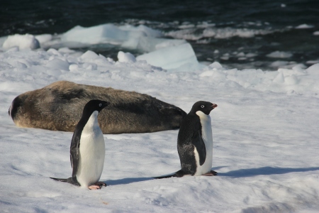
While walking around the point, some friendly penguins and an elephant seal appear. Credit: Clément Miège

Lynn, Clem, and Rachel come over a hill while walking around the point. Credit: Bruce Wallin

Bruce snowboards on a sunny Sunday afternoon at Vals. Credit: Bruce Wallin

Lynn releases a radiosonde, which is done every morning on base as part of the meteorology observations. Credit: Lynn Montgomery

An impressive spread for Thanksgiving dinner hangs on the wall (top left); Bruce, Ted, and Lynn are very thankful about the dinner after a long day of training (top right); this is a typical Smoko meal (bottom left); and some state flags hang in the dining room (bottom right). Credit: Ted Scambos and Lynn Montgomery


